Day 2 - Kham Duc to Tam Ky (or return to Da Nang/Hoi An)

Nui Xuan Mai rising above Dak Mi 4 Reservoir.
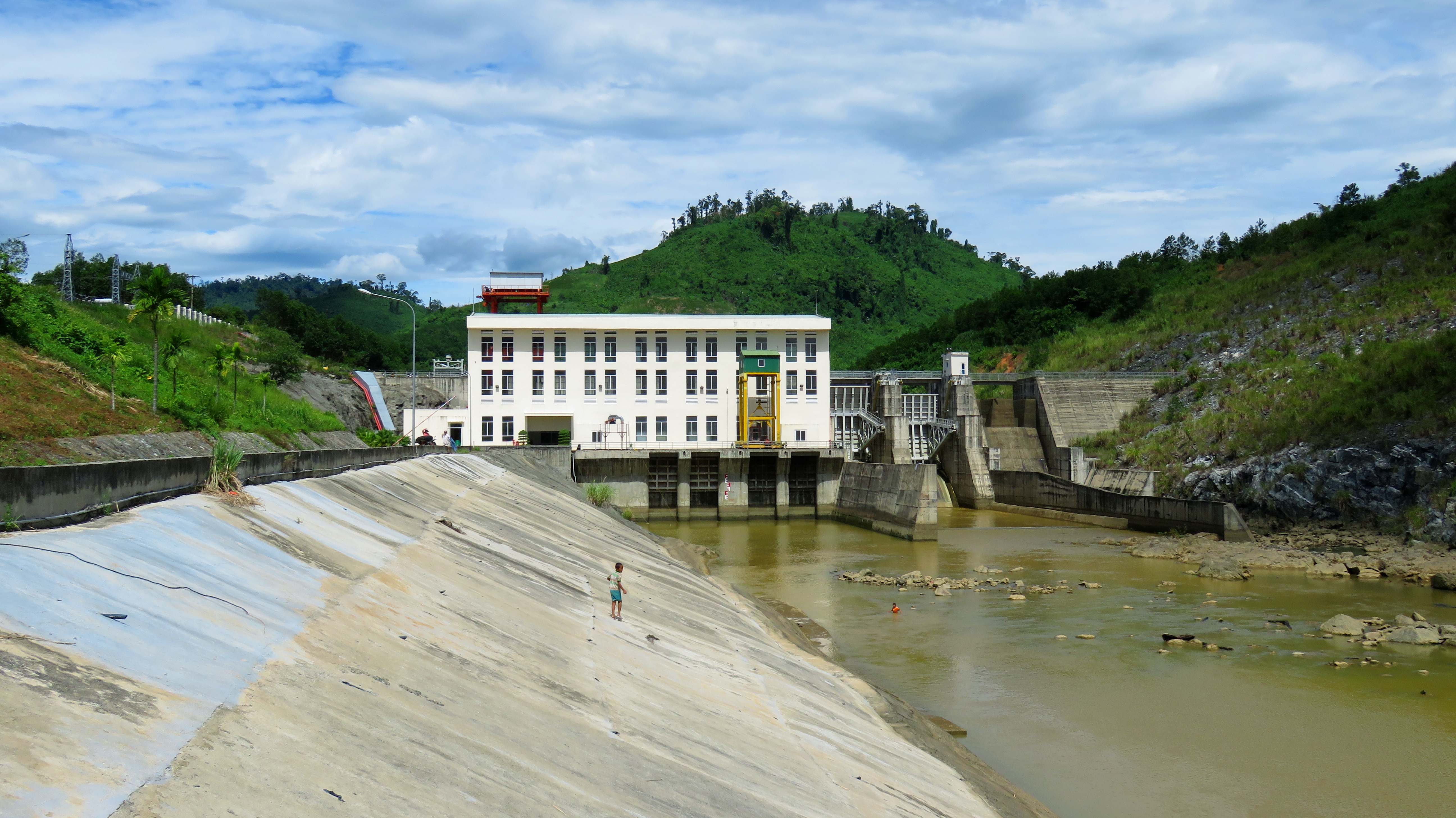
Day 2 of the Dak Mi Loop should start early if you are trying to get back to Da Nang or Hoi An that day. If you are planning on a third night in Tam Ky, then there's no rush. Heading out of Kham Duc, it's back down the hill towards the river. At the intersection, turn right onto DT-14-E. The road goes across the top of the Dak Mi 4 Dam, which is pretty impressive. It's a large dam, quite high, and it looks like it could be fairly deep. Perhaps 50 to 75 meters most of the time? Certainly over 100 m at full pool. We stopped for a few photos, and the Nui Xuan Mai rising behind the lake was quite photogenic. These granite peaks top out at 1865 meters, or around 6,120 feet, and rise rather abruptly from the surrounding areas.

View down the Dak Mi River Valley from the top of the dam.

Looking down the spillways.
|

Rob Anderson on the Dak Mi 4 dam.
|
The road wanders up and over a small pass, crossing over a low shoulder of the big peaks. The views are great in all directions; not only are the peaks and their majesty great to look at, but the view back to the west and southwest over Kham Duc, and the large mountains that rise behind it, is just as good. The Dak Mi 4 Lake filled up a narrow gorge on the Dak Mi River, and because of that it flooded quite a few forests on it's slopes. Since this reservoir is still new, you can still see these "skeleton forests" rising from the waters of the reservoir. Ghost trees, a lake, jungle, and mountains together, it sure is a great view.

Ghost trees and big mountains. Phuoc Son District is quite beautiful!
|
Once over the hill, the road quickly drops down into the valley on the either side. It's interesting to note just how much higher in elevation the Kham Duc area is, as you drop quite a ways down into Phuoc Hiep and Hiep Duc. On this side of the divide are several small villages, but hidden in the rolling hills and folds of the earth are three smaller hydro reservoirs. The powerplant for the Dak Mi 4 Lake [the big one you crossed over earlier] is actually located on this side of the drainage, and not in the drainage of the Dak Mi River itself. Between the three power plants of Dak Mi 4, Dak Mi 4b and 4c, the entire cascade can produce up to 208 Megawatts at full bore, although they usually operate at quite a bit less. The first of these powerplants you are not allowed to visit, but the lower ones you can see from the road.

Dak Mi 4 Project map. Image source: Dak Mi 4 Project Description Document.
|

Village under the shadow of Nui Xuan Mai.
|

One of the eastern summits of the Nui Xuan Mai.
Below this project, it turns into rural Vietnam and stays that way for a long ways. The dramatic Xuan Hai Mountains in the background eventually get smaller and smaller in the distance, and the view ahead is replaced with low ridges and rolling hills. Looking off to the north you can soon get a view of the Hon Kem-Da Dung, which is an impressive canyon cut through a range of mountains. The small river you are following slowly gathers more and more feeder streams coming out of the low hills until it is actually a decently sized river in itself. There are several classic government suspension bridges along this stretch, built to access local villages across the river. We walked out on one because the views are usually quite good from them, and some of them are quite airy, with lots of vertical beneath them.

Bridge across the ngọn Thu Bon.
Dak Mi 4c hydroelectric power plant.

Local village bridge.
|

ngọn Thu Bon getting larger....
|
|
A funny note about the river here- the stream you've been following is actually a fork of the Thu Bon River, the very same river that flows through Hoi An. This is not the main stem, nor even one of it's primary tributaries, but just a typical fork, but it's name is "ngọn Thu Bon", which translates to "tasty Thu Bon". So, I guess it is the "Tasty Fork of the Thu Bon". Not the most sensical but one of the more humorous for sure, I'll take it. The road keeps rolling through lots of small hills and valleys. It's all very similar, but it is beautiful. Eventually in here you cross from Phuoc Son District into Hiep Duc District.
|

Rob on a quick break.
|

After a while ofthe rolling hills, they finally break away a little bit and you reach the open valley of the Thu Bon River floodplain. A large bridge crosses high above the river, and one can only imagine what a massive this river must be at flood stage to build a bridge so high. Just across the bridge is the bustling and growing town of Tan An, the district for Hiep Duc. We were driving through, and were intrigued by a large temple-looking structure we could see from bridge on a hill above town. It turned out to be a memorial temple for those who died during war time, and since it sits on a large hill above the surrounding area, it has a commanding view to the north, west and south.

The mighty Thu Bon River, much higher up in the drainage from Hoi An.

Hiep Duc temple from far away.....
|

....and up close.
|

Tan An town and rural Hiep Duc District in the process.

Looking west through Hiep Duc and into Phuoc Son.
Options
Once you've reached Tan An, you've got a choice to make in regards to how you will proceed. Over the next 20 kilometers of road, you've got a choice between 4 routes that will take you back to Highway 1A. Each represents different advantages and drawbacks, so let's take a closer look at the options.
DT-611BThis road is probably the quickest back to Da Nang or Hoi An. Turn left 9 km east of Tan An. This road soon joins up with DT-611 in Que Son, and it's less than two hours back to Da Nang.
DT 614 -> DT-615
This road first turns south, and cruises along the Tien Phuoc Valley, before turning east at Tien Cam and crossing over a small pass before dropping onto the coastal plains and joining QL-1A just north of Tam Ky City.
|
QL-14-E
Alternatively, you can stay on the 14-E, and continue all the way to Ha Lam town on QL-1A. There's not more than 10 km difference between this and the 611-B, however driving through Ha Lam town can sometimes be quite busy.
DT-614 -> DT-614
Or, you can continue 10 km further up the beautiful Tien Phuoc Valley to Tien Ky before turning east. On the other side of the pass is Ho Phu Ninh, the beautiful and famous lake, and just past the road joins QL-1A in downtown Tam Ky City.
|

Bamboo grove along DT-614.
|
For this trip we chose option 3, the DT-614 to DT-615 route. We wanted to catch the sandbar road that goes north up the coast fro Tam Ky back home to Da Nang, so that was our most direct and quickest option to get from A to B. The drive up the Tien Phuoc Valley was incredible. Lots of fun, twisty, windy good roads, and plenty of beautiful small falls, villages and fields hidden amongst the trees and the bamboo groves. It was a long 14 kms to Tien Cam, as we crossed over two separate small passes along the way. Good views to the mountains to the west reveal themselves once in a while.

Typical small farm along DT-614.
|

Beautiful rice paddies along DT-615 outside Tien Cam.
Finally we made our turn, went up one more small pass and at the top were greeted with a great view of Tam Ky City laid out before us on the coastal plains far below. After a little bit of harassment from the locals who were hanging out at the top of the pass, we dropped down and into town. I wanted to see the Cham towers at Chien Dan, so we made a quick 2 minute detour north to check them out. Although they are in various stages of disrepair, any Cham site intrigues me so it was nice to see. You can read more about Chien Dan here.

Looking down the hill at Tam Ky City in the distance.

Cham towers at Chien Dan.
After a quick late lunch in Tam Ky, it was time to keep a move on and get home. We wandered around through the estuaries of the Ban Thach and Truong Giang Rivers for a while, enjoying the views and hoping the looming rain clouds would hold off just a little more. We reached the sandbar road, Thanh Nien Street, in good time, and began driving north. This is a beautiful drive, and while it rarely affords views of the coast and beach, it is just 50 meters to the east, and every 5 to 10 kilometers a road takes off and goes over to it. The road passes through numerous smaller villages, past innumerable tombs and pagodas, and through a beautiful coastal pine forest along the way. This road goes almost all the way to Hoi An, and once you get close enough several different roads cut west, over to the new high speed road that connects Hoi An and Tam Ky. From here it's just a quick dash over the Cua Dai Bridge and into Hoi An.

Aquaculture in the estuaries of the Song Truong Giang.

Local boats on one of Thanh Binh's beaches.
|

.....and looking back towards Da Nang.
|

Looking up the now much larger Thu Bon River. Hoi An is on the right side of the frame.

Closer view of Hoi An Ancient Town.
If you choose to stay in Tam Ky, it allows for more possible local adventures that afternoon or the next day. Tam Ky has a good amount of things to see and do, including another set of Cham towers at Khuong My, the aforementioned Phu Ninh Lake, the large river delta at Nui Thanh, and the art village in Thanh Tam. Supposedly there is some great rock formations to see in Tien Phuoc District, but I don't know much about them yet. There is plenty of reasonable lodging in Tam Ky, but for those looking for a bit more luxury, consider booking a night at Le Domain Tam Hai, a beautiful resort not too far away, tucked away in the forests of Tam Hai Island. Once you've had your fill of Tam Ky, simply turn north and head back to Hoi An or Da Nang!
The Map
All photos copyright Kit Davidson unless otherwise noted.
All maps copyright and courtesy Google.
Dak Mi 4 Project Map source:
https://cdm.unfccc.int/filestorage/R/X/S/RXSVEHO5P24Z1JYC8NDITA0UKWMG93/%28clean%29PDD%20Dak%20Mi4%20version%202.0%20corr.pdf?t=eDl8b2RidmhwfDCx8lcYmFcccnkdU4NYuLF6
All maps copyright and courtesy Google.
Dak Mi 4 Project Map source:
https://cdm.unfccc.int/filestorage/R/X/S/RXSVEHO5P24Z1JYC8NDITA0UKWMG93/%28clean%29PDD%20Dak%20Mi4%20version%202.0%20corr.pdf?t=eDl8b2RidmhwfDCx8lcYmFcccnkdU4NYuLF6
