"The Valley of the Yellow River"
Xa Ba / Xa Tu / Thon Vau

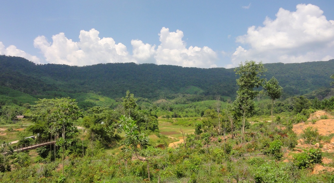
Tea fields near Xa Ba. Nui Chua (Ba Na Hills) in the background.
In the mountains west of Da Nang, there is a beautiful valley that spreads for miles and covers a handful of river and creek drainages. These drainages all pool together near the town of Xa Ba (Town 3), to form the Song Vang, or Yellow River, before it turns and cuts into the mountains to the south. These shallow, rolling valleys, similar in nature and scenery, are an interestingly placed anomaly compared to the areas around it, and exploring through the quiet villages and groves of this area is not only a peaceful and wonderful activity, but also provides some interest to geology nerds.
Geologically speaking, to the west of Da Nang there exists a large chunk of rock (quite possibly a batholith) that has been uplifted to produce some sizable mountains and mountain ranges. This collection of peaks, which we could call the Nui Chua - Nui Mang - Nui Dai Loc massif, stretches between the Cu De River to the north and the Vu Gia River to the south, and from P'Rao in the west to Hoa Vang in the east. It's a sizable chunk of rock, and for the most part, is predominantly granitic bedrock. However, in the middle of this massif, almost entirely surrounded on all sides by that granitic bedrock, there exists an isolated area of sediments that are much different from the surrounding rock. It's different aged material, and when you know what you are looking for, the difference between the two rock types is quite visible.
Geologically speaking, to the west of Da Nang there exists a large chunk of rock (quite possibly a batholith) that has been uplifted to produce some sizable mountains and mountain ranges. This collection of peaks, which we could call the Nui Chua - Nui Mang - Nui Dai Loc massif, stretches between the Cu De River to the north and the Vu Gia River to the south, and from P'Rao in the west to Hoa Vang in the east. It's a sizable chunk of rock, and for the most part, is predominantly granitic bedrock. However, in the middle of this massif, almost entirely surrounded on all sides by that granitic bedrock, there exists an isolated area of sediments that are much different from the surrounding rock. It's different aged material, and when you know what you are looking for, the difference between the two rock types is quite visible.

Xa Tu Village
|
One of the main roads from Da Nang to the Ho Chi Minh Highway corridor, as well as the numerous villages and ethnic areas in Dong, Nam, and Tay Giang districts of Quang Nam, is the 14G. This road takes off from the AH-17 in the small town of Tuy Loan, and there are a number of small towns spaced along it's length between Da Nang and P'Rao. One of these towns, called Xa Ba, is the local center of activity for the area, and it is from here that you can fan out and explore this area of sediments suorrounded by other rocks.
Xa Ba is neat in and of itself because it is the center of the local tea plantations, and the fields are filled and the hills are terraced with aromatic tea fields. Along the main road at the edge of town are several tea processing houses, which are fun to drive by because of the powerful and pleasing aroma that permeates the air from them. Often times you can smell them even as you drive by. There is an interesting totem-pole like object in the center of town that is a marker and monument to the local ethnic peoples, of which locally there exist members of the Co Tu, Ba Na, and Lao peoples, amongst others as well. |

Marker to local the local ethnic peoples, Xa Ba
|

Somewhere along the Song Vang
North of Xa Ba, and a little west, along the headwaters of the Song Vang, is the village of Xa Tu. The town itself is spread out along several kilometers of the road, and lacks a true "core" area. It is in this area where some of the drastic geologic changes are visible. Not because of visible geologic features, however. The river bottoms along the Song Vang in this area have been dredged out a bunch, in an attempt to gather the gold that has been washed down from the granite peaks above. So while there are beautiful mountain peaks rising in the background on all sides, the rolling hills locally give way to a dredged-out river corridor. Numerous dirt roads head off in all directions, venturing out to small farms, mining operations, and logging plots. There is a fairly new river crossing here that has been wrecked by the river. There is a major tributary valley to the one that holds Xa Tu, rising to the west along the backside of Nui Mang, but I have yet to explore up there.

|

|
Clockwise from top left: The wrecked bridge in Xa Tu; Kelsey on the old suspension bridge; a local Communal House in Xa Tu; and Kelsey somewhere in Xa Tu with Nui Mang behind.

|

|
Nearing the ridge that separates the Song Vang from the South Fork of the Song Cu De
Thon Vau & the Tam Riong Valley
And then, to the north and a little east of Xa Ba, in the next valley east of Xa Tu, lies the village of Thon Vau. This is a remarkably authentic area, with wooden houses and plenty of rural Vietnam charm. A neat suspension bridge connects to a small hamlet across the river at one point. For all the places in Vietnam that have modernized, with fancy five-star resorts and sweeping futuristic bridges, this is a good place in the greater Da Nang area to go that is still as it was fifty years ago. Take away the electricity and the motos, and this place would like right out of 1925. It is somewhat remote and not likely traveled by many Westerners. The one downside to the area is the trash. It can be bad in some spots. But if you are willing to overlook it, you'll find a pretty incredible place.

Downtown Thon Vau

Tyler on the suspension bridge to the other village
One of the real charms of Thon Vau, however, is at the end of the road. The village ends, and a large field opens up with the mountains behind it. A river placidly meanders through the middle of the field, and there are several dirt tracks that offer a multitude of hiking options. It is a wonderful scene and well worthy of a visit. When we were there one time we communicated with some of the locals, and from what we gathered, somewhere in the hills above the village was a waterfall called "Thac Do". Over the next couple of trips we ended up finding it, and it wasn't quite what we thought. Rather than being one single dramatic falls, it ended up being a whole wall of rock, covered in vegetation, through which a thousand streams sloped down the rock. I have only seen it in summer time but I can imagine in winter it must be pretty amazing.

Downtown Thon Vau again

Thon Vau's central park panorama
Outside of Thon Vau, the road deteriorates into a rough two track, but it keeps going into the forest for quite a ways. We chose to take a fork that took us first to a beautiful, wide open field of something similar to wheat, before giving us a good close up on Thac Do. There are other forks that branch off towards other upper arms of the valley, but I have yet to go in those. Once across the river outside of town, it gets quiet and feels extremely peaceful.

Thac Do, high above Thon Vau

Tyler at the end of the road
All photos copyright Kit Davidson unless otherwise noted.
