A Story of a Hydropower Project and Resettlement Villages
|
During my collegiate career, I had to write a scholarly review about a research paper, and having just spent six months before hand in Vietnam, I was keen to write about something from the Land of the Golden Dragon. Eventually I came across an article written about the displacement of ethnic local people from their homes and lands as a result of hydroelectric reservoirs flooding former fertile river bottoms where those people had lived for generations, and the struggles they faced once in these new villages.
|

|
One of the situations that was mentioned in the article was taking place west of Da Nang, in a mountainous area of northwestern Quang Nam, centered around a hydropower project called the A Vuong 1. This project, which created a reservoir nearly 100 meters deep and 6 kms long, meant flooding a very fertile and beautiful stretch of the A Vuong River, a major watershed in Quang Nam's Dong Giang & Tay Giang Districts, as well as the several small local villages scattered along those river bottoms. Two of these villages, Alua and K'la, were at the center of the issues the article I chose to review talked about. This was a perfect example of the conflict between modernity and traditional existence that is happening in so many places around the world. So not only was I keen to see the situation I had previously read about with my own eyes, but as someone who also is interested by civil engineering, the dam, reservoir, and power project were also new projects to learn about and see up close.

A Vuong Reservoir.
The A Vuong River traces it's headwaters out of the mountains that lie on or near the Laos-Vietnam border. The streams slowly come together in Quang Nam's Tay Giang District, before turning north, cutting a beautiful canyon through the foothills north, and then east, of the Bol Kin [or Nui Kin] massif. It cuts another beautiful canyon below the modern town of P'rao, then opens up into a valley and finally cuts into it's largest and deepest canyon before it joins the Bung River west of Thanh My, Quang Nam. Along the way, the river has thus far been impacted by two hydropower projects, and a third is taking shape as of this writing. The other existing of these is found In the canyon below P'rao, and just upstream of A Vuong Reservoir, where a small dam has been built, with a small run-of-the-river project hydro project there called Za Hung. This project is quite small and hasn't impacted too many people with it's construction. However, downstream is a different story.

A Vuong River north of P'rao.

|

|

|
L -> R : Za Hung Reservoir, Za Hung Dam, Za Hung Power Plant.
The A Vuong 1 Project is quite large for this part of Vietnam. Its biggest impact was the creation of a reservoir nearly 100 meters deep, 7 kms long and 12 kms wide, called A Vuong Reservoir. The power plant fed by this lake can generate up to 210 megawatts of electricity at full bore, although it typically generates around 800 million kvh most of the time. The project utilizes a standard "run of the river" scheme, which involves a retention dam to feed water to some inlet tubes, or penstocks. These penstocks then funnel that water under the mountains, where it then freefall drops down to turbines inside a waiting power plant on the other side. Most run-of-the-river systems generally prefer to place the dam at the end of a valley where possible, at the head of a canyon, so the dam size to reservoir size is extremely favorable, and A Vuong 1 is no different. The dam straddles the very head of the A Vuong River's last great canyon before it joins the Bung River downstream. The power plant itself is inside the canyon of the Bung River, after their confluence.
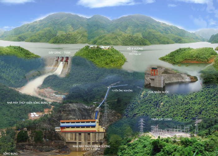
How the system works: A Vuong Dam (upper left) makes the lake, which feeds the Penstocks (upper right), which drop down to the power plant (bottom center) which delivers power to the grid (bottom right). Photo copyright Thuy Dien A Vuong. (picture found http://congty43.com.vn/Images/Products/ToanCanhCongTrinh.jpg)

A Vuong Reservoir.
In a pure power sense, these schemes are quite efficient. Let gravity do the work, just channel the water a little bit and bam, energy. However, in an ecological sense they are incredibly destructive. The obvious glaring issue is the flooding of valleys and river canyons, displacing people and animals, and covering precious crop land. In addition, the removal of the water from a stretch of the riverbed can also be destructive not only to the local environment that relies on the river for water, access, nutrients, etc, but also to the aquatic ecosystem of the former riverbed itself. These factors, coupled with the social issues of displaced peoples, makes these projects hot spots for a discussion on modernity vs. traditional values, and the resettlement of the people and villages in the A Vuong are just a microcosm for a very common theme around the world.

Old houses near the old town of Thon Den.
 Traditional K'tu forest house.
The problem with the resettlements here is the new villages that are built by the government (with money from the companies that built and manage the A Vuong Project), are located in terrible locations for living. The locals' previous homes in the valley bottoms were located on flat ground, with plenty of acreage for crops and livestock, well watered and possessing soil rich with nutrients from the yearly river floods. However, the new villages were built on the side of the hill, directly above the shores of the reservoir. There is no land for agriculture or livestock raising. There are water distribution problems. There are landslides that periodically destroy homes and carry off villagers. The roads are built over rocks and boulders and deteriorate rapidly. The local people also have a very strong sense of community, and villages almost always sit in a circular shape, surrounding the circular Goul, or communal house. However, these new resettlement villages are merely lines of houses spaced along a straight road, and there is no feeling of shared community, especially since they are without a central Goul. The villagers were faced with a terrible choice: stay in these new villages, with no soul or sense of community, plagued by issues with nature; leave and try to remake their lives in a new village, built from scratch; or abandon their way of life and move to a larger town such as P'rao, Ma Cooih, or Thanh My. People should never have to make such a terrible choice. Google MyMaps has given us a good view of where the villages were pre-reservoir, and then where the reservoir is, with the resettlement villages.

Location of old villages along A Vuong River valley.

A Vuong Reservoir and Hydro Project, with resettlement villages around it.

|

|
Clockwise from above: Penstock [water inlet]; A Vuong 1 Dam; Island in the lake; A Vuong River Gorge.

|

|
So when I was out in that part of Vietnam recently, I set out to go have a look for myself what was happening. My main questions to answer were these: What have the local villagers done with their lives since the paper I read was written? At the time of the papers' writing, the locals were faced with a difficult choice. What choice did they make? Where were they now? Getting all of these answers seemed like a tough task. Even getting out to the villages presented a somewhat difficult challenge. The A Vuong Valley is located in far western Vietnam, so I first had to drive almost three and a half hours just to reach the reservoir. From there, it was another hour drive along the newly built reservoir to reach the bridge across the lake that accesses the resettled areas. Along the way I drove by both the penstock inlets, where the water actually leaves the reservoir for it's trip under the mountain, as well as the dam itself. The road went right across the top, and while they said no pictures, I couldn't help but take a photo of the beautiful and massive canyon downstream. The water of the eastern A Vuong Reservoir possesses a brilliant blue-green, almost aquamarine color to it. This is thanks to the dissolved limestone in the water, which exists because of the random limestone streak that slices through the area.

A Vuong Reservoir color.
|

A Vuong Reservoir.
|

Bridge to resettlement villages.
|
Once at the bridge, which was exceedingly loud by the way, it's hard to immediately tell that the villages across the lake were abandoned. I could see the squat, identical houses all lined up, but something just didn't feel right. There was no laundry hanging. There were no animals. No one was wandering around. Driving across the bridge it felt like driving into a ghost town. Once across I realized that these villages had been abandoned already. These villagers had made their choice. And it was pretty easy to see why. The road is in terrible shape, potholes and boulders, and the village lacks a soul. It just feels strange, alien, like it doesn't belong there.

Most of the abandoned houses didn't have floors.
|

Bridge over the reservoir.
|
|
So where were the villagers? Had they all packed up and headed out to parts unknown? It was clear these villages hadn't been occupied for a couple of years anyway; considering they were only built between 2004 and 2006, there was enough wear and tear to see that they hadn't been lived in any time recently. Curious, I noticed a road headed up the valley, past the end of the reservoir. I hadn't seen anyone in some time, so I didn't know whether there was a village further up or if the whole area was now just uninhabited, but I was keen and started driving up the road.
|
|

Resettlement village.

On the road past the reservoir.
A couple of kilometers later, up some dirt but not overly bad roads, I came around the corner and there, perched on a clearing on top of a small hill, was a local village. It looked fairly new, with all of the wooden shacks all having new green tin metal roofs. At this point I was separated from the village by a creek and small valley. The final drop down to the creek and then back up was pretty rough, and took some time. Once on top I hung out for a few minutes and took a couple of photos of the village. It was wide, built in a circle, and had the traditional goul in the middle. There were areas for crops (certainly not as much as they had enjoyed before, but still more than the village above the lake shore) and there was a road taking off up the hill towards more villages deeper in the mountains. So the villagers here, whilst being taken off their original, traditional land along the river bottoms, had eschewed the government-built housing on the lake and decided to make their own fortunes by clearing a plot of land and building a new village. While it isn't ideal, they've certainly done the best they can do, although it's a shame they've had to do it at all.

In the new village up the road.
|
I didn't go in too much, as I didn't want to be a disturbance. So I took a few photos, admired the village a bit, and then headed out. It's clear that this village has rebounded nicely, at least in it's physical setting. However, without being able to speak the language (which, out here is more likely to be K'tu than Vietnamese) there is no way to know how the rest of the transformation has gone. How are the villagers settling in? What are their lives like in this new village, compared to the original village pre-reservoir, as well as compared to the resettlement village?
|

Sleepy village.
|
What challenges are they facing now? Are they thriving or surviving? There are so many questions I would like to ask. However, some of my questions have been answered, and while it hurts to see these people having to leave their traditional homesteads, it's better to see them here, in their new village, rather than in a terribly-placed, ill-equipped soul-less resettlement village.

Goul and village center.
|

I passed a friendly family of hogs on the way out.
|
Unfortunately, the ending here is not indicative of how all the hydropower displacement stories end. In this case the locals had the space and the ability to create a new village not far from their original homes, but in other situations around Vietnam, and around the world, displaced villagers don't always have a place to go outside of the resettlement villages. These people are then forced to live in places that are not conducive to thriving at life, or they have no choice but to leave for other places. This leads to the destruction of their traditional way of life, and culture, and breaks up families and communities. Fortunately, the dam building movement across Vietnam seems to have abated a bit, and while there are a few more being built as we speak (including one high in the A Vuong River drainage) the big push to build as many as humanly possible in Vietnam's mountains has kind of backed off a bit. Hopefully this is a sign of the way things are changing to, and not just a brief pause, for far too many people have been displaced already, and too many ecosystems have been destroyed, and it's time to put a stop to these ecological nightmares.

Final look at the Kingdom of A Vuong on the way out.
Interactive Map
(be sure to click on the upper left corner so you can utilize the different layers of the map!)
All photos copyright Kit Davidson unless otherwise noted.
All maps made with and copyright Google MyMaps.
All maps made with and copyright Google MyMaps.
